Friday, June 25, 2010
End of the road
Day-14 Itinerary
Friday, June 25
Estimated 5 hours (327 miles)
Crossville, TN (elevation 1,895) Roanoke, VA (elevation 935)
Roanoke, VA weather:
90/70(high/low)
Isolated Thunderstorms
30% chance of precipitation
Little Rock to Crossville
Thursday, June 24, 2010
Day-13 Itinerary
Thursday, June 24
Estimated 7.5 hours (461 miles)
Little Rock, AK (elevation 482) Crossville, TN (elevation 1895)
Crossville, TN weather:
90/70(high/low)
Isolated Thunderstorms
30% chance of precipitation
Wednesday, June 23, 2010
Amarillo to Little Rock
It was a long day of driving today, but not our longest so far. Fortunately, the last two legs of our trip will be progressively shorter—but unfortunately hotter and more humid.
I had the first shift of driving today. Somewhere in Texas between Amarillo and Ft. Smith, while all of my passengers were taking their morning naps, I saw the "world's largest" crucifix not farther than 100 yards from the eastbound land of I-40. It must have been close to 200 feet tall. Very ominous and kind of creepy. It looked to be part of a partially built octagonal Christian church of some micro-denomination of which I can neither recall nor have ever heard of. Seems they spent all their money on the giant cross and ran out of money for the actual church. Makes you wonder.
Further east we saw a very large wind farm—each turbine about the size of the giant cross. There must have been at least 100 of the them and they stretched on for 10 miles or so. It was nice to see these among all of the oil wells that we saw. They look a lot nicer too.
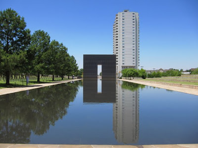
I'd have to say that besides the giant cross and the the wind farm and learning that Oklahoma has mountains (!), today's highlight was our brief stop at the National Memorial at Oklahoma City. It was very moving to be there (and hot). I really loved the design of the memorial.
Tonight, Sidney and Samuel went swimming in the luke-warm water of our campground's pool. The rest of us drank whatever alcohol we had left, grilled hamburgers, and I made another mess of cowboy beans. The air is filled with the sound of cars on the nearby freeway and the roar of chirping insects in the surrounding trees.
Tomorrow we reach for Crossville, Tennessee. Our current plan is to stop in Memphis for a quick look around and lunch at Neely's Bar-B-Cue. In Nashville, we'd like to go by our old house in River Ridge that we haven't seen since 1987. Hopefully, it is still there after the recent flooding. We'd also like to show the kids around Music Row, the Ryman Auditorium, Ernest Tubb Record Shop, and maybe the Loveless Cafe. We'll see how much we can accomplish given the time we have left.
Tuesday, June 22, 2010
Day-12 Itinerary
Wednesday, June 23
Estimated 9.5 hours (596 miles)
Amarillo, TX (elevation 3,736) Little rock, AK (elevation 482)
Little Rock, AK weather:
97/77 (high/low)
Sunny
0% chance of precipitation
Sante Fe and Amarillo
Itinerary Update
Day-11 Itinerary
Tuesday, June 22
Estimated 10 hours (611 miles)
Bernalillo (Albuquerque), NM (elevation 5,312) to Choctaw (Oklahoma City), OK (elevation 1,230)
(via Santa Fe, NM)
Oklahoma City, OK weather:
0/0 (high/low)
Condition
0% chance of precipitation
Oklahoma City East KOA Kampground
6200 South Choctaw Road
Choctaw, OK 73020
405-391-5020
Monday, June 21, 2010
Grand Canyon to Albuquerque
Sunday, June 20, 2010
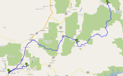
Capital Reef to Zion National Park via Bryce Canyon
Day-9 Itinerary
Monday, June 21
Estimated 7 hours (417 miles)
Grand Canyon Village, AZ (elevation 6,800) to Bernalillo (Albuquerque), NM (elevation 5,312)
Bernalillo, NM weather:
0/0 (high/low)
Condition
0% chance of precipitation
Alburquerque North/Bernalillo KOA Kampground
555 South HIll Road
Bernalillo, NM 87004-9120
505-867-5227
Saturday, June 19, 2010
Day-8 Itinerary
Saturday, June 19
Estimated 5.75 hours (280 miles)
Torrey (Capital Reef), UT (elevation 8,000) to Springdale (Zion), UT (elevation 4,000)
(via Bryce Canyon and St. George, UT*)
*Meet Drew in St. George, UT at 6:15 PM
Springdale, UT weather:
94/63 (high/low)
Sunny
0% chance of precipitation
Zion Canyon Campground
479 Zion Park Road
Springdale, UT 84767
435-772-3237
Friday, June 18, 2010
Goblin Valley and Capital Reef National Park
Day-7 Itinerary
Day 6
Friday, June 18
Estimated 2.75 hours (156 miles)
Moab, UT (elevation 4,026) to Torrey (Capital Reef), UT (elevation 8,000)
Torrey, UT weather:
76/51 (high/low)
Mostly sunny
0% chance of precipitation
Thousand Lakes RV Park
996 W State Road 24
Torrey, UT 84775
435-425-3198


